Stephen Martin Saxby
1870
In December of 1868, Stephen Martin Saxby, a navigator in the British Navy and amateur astronomer, first wrote to a London newspaper warning of a storm that he predicted would hit the eastern seaboard of North America on October 4th or 5th, 1869.
Saxby predicted that the position of the sun and the moon, relative to the earth, on those dates would cause extremely high winds and huge tides that would cause severe flooding in the affected areas. Very little attention was paid to Saxby's warnings and the people living along the Fundy Coast, who would suffer the most when Saxby's prediction came true and a storm did indeed strike on that date, would not become aware of Saxby's prediction until after the storm had struck the area.
Saxby's prediction became a reality due largely to chance rather than solid scientific observation. On the date predicted, thunderstorms carrying moisture were moving West to East across the North American Continent. At the same time, a tropical storm from the Caribbean, was moving up along the Northeastern Seaboard heading towards New Brunswick. The two storms met south of Saint John on the morning of October 4th, 1869 and combined to create a cyclone. Wind gusts at sea during the storm reached 200 kilometers per hour. Many of the vessels out at sea were lost, along with their crews. The storm caused severe flooding along the Fundy Coast as the normally high tides at that time of year and the high winds caused by the storm combined to create a surge of water. Over the next two days as the storm traveled up the funnel shaped Bay of Fundy the low lying areas of Albert County and surrounding counties continued to be flooded. The storm brought with it the highest tides ever recorded along the eastern seaboard, along with high winds and heavy rain. Some areas received over 300mm of rain in one day.
Painting depicting a house being lifted and swept away from its foundation by surging tidal waves.
2003
In Albert County residents "battened down the hatches" for what they thought would be just another fall gale. According to legend as the wind and the waves began to rise one lone Indian left his village and started to canoe up the Petitcodiac River. Soon he found it too difficult to battle the current so he landed his canoe at a small creek . He then turned over the canoe and slept under it, the next morning he awoke and found himself a mile inland with no sign of the small creek. As the intensity of the storm grew, breakwaters built out of large boulders were destroyed by massive waves, and many docks were damaged. Lobster traps and other fishing equipment stacked up on shore and on the docks were washed away. In addition boats tied up at the docks or hauled up on the shore were soon smashed by giant waves and dragged out to sea. Other vessels were set adrift only to run aground miles inland from the shore. Across the Petitcodiac River in Memramcook a large ditch had to be dug across the marsh from the river to the spot where a large sailing vessel had been grounded on the marsh by the storm in order to get the ship afloat once again. The dykes which had for years battled against the tide to keep salt water off the marshlands were soon washed over by the extremely high tides, and parts of the dykes were destroyed. The sea water which now covered the marsh killed a large number of livestock because much of the cattle from the farms in the area were still out to pasture on the marsh when the gale struck. Most of the homes in the area were built quite far back from the coastline and were safe, but many of the houses that were built closer to the shore, along with other buildings, were washed away in the storm surge. Another legend tells of how the storm settled a domestic dispute between a new bride and her husband. The new bride had requested that the kitchen window of her new house face north because she liked the view from the north side of the house best, the husband argued that building the house with the window facing north would make the house cold and he instead built the house with the window facing south. When the house was finished the bride left her new husband alone in thehouse, and went back to her mother's house. When she returned after the storm the tide waters had rotated the house around so that the kitchen window was now facing north, so she got her wish after all.

Painting depicting a man trying to avoid being swept away by flood waters caused by the Saxby Gale.
2003
In Hillsborough the low lying marshlands below where the Salem & Hillsborough railway museum is now located, became a "lake" of sea water during the storm. The Hon. John Lewis owned a store which was located on this marsh. During the storm the two storey building had its windows and front door driven in, then the store filled with water and mud. Even the dishes on the top shelf were filled with mud. The store warehouse, located near the store, and two other houses which had been built on the marsh were lifted from their foundations and floated farther inland up the artificial "lake" before coming to a rest on higher ground.
Many farm animals in the area around Hillsborough lost their lives because of the storm, including a group of chickens whose hen house was found after the storm stuck six feet up in the air in a tree. The first human deaths caused by the storm also occurred in Hillsborough when a young couple tried to cross the artificially created "lake" on the marsh flats. The couple were returning home in a horse drawn buggy from a dance when they decided to try and cross the "lake". Before they made it across the marsh the horse and buggy were swept away, in the confusion the man lost sight of the girl and she drowned. He was saved by holding onto a piece of wreckage and floating to safety.
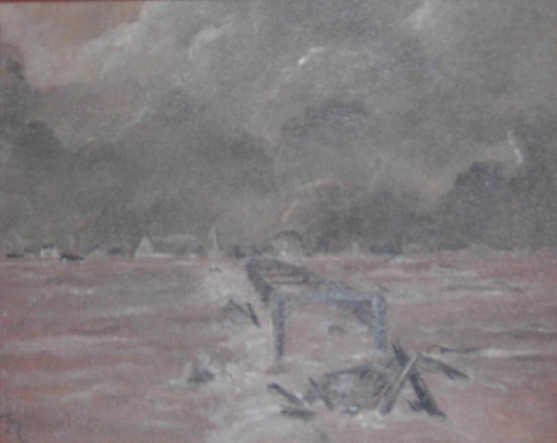
Painting depicting the destruction of Gunningsville Bridge in Riverview caused by the Saxby Gale.
Riverview, Albert County, New Brunswick
In Riverview the tidal bore which had long been of concern to the sailors of the Petitcodiac River, now because of the high tides and wind became a powerful destructive force. The storm caused a tidal bore which has been estimated to have been ten feet high. The tidal bore traveled up the river and destroyed the bridge crossing between Riverview and Moncton.
Farther up the Petitcodiac River tragedy struck again. Jacob and Ellen O'Brien and their six children lived in a small house at the Salisbury end of Coverdale. The family was awakened in the middle of the night by the sounds of the roaring gale. They soon discovered that their house was surrounded by water, so they frantically built a small raft out of two fence rails, and latticed it with kindling sticks, they then set out for the safety of the shore.

This painting depicts rising tidal waters flooding a farm house during the Saxby Gale.
The two smallest children were placed on the raft while the other children were told to hold onto the sides of the raft. Once the family had cleared the shelter that the house provided against the wind and raging waters, they were swept up by strong currents. The currents proved too strong for the children, they each lost their grip on the raft and were swept away one by one in front of their parents. The next day the parents and the two small children returned to find that the house was still standing. Every year in the fall when the tides of the Bay of Fundy reach their highest levels and hurricanes travel up the coast from the Caribbean, the residents of Albert County cast their eyes out into the Bay of Fundy and begin to retell the stories of the Saxby Gale.